Observations on Achnanthes armillaris
Protisten / Protisten.de – created by Wolfgang Bettighofer / Bacillariophyta / Bacillariophyceae / Achnanthes armillaris
Position in the EOL taxonomic tree. Please click on the tree view below to access EOL (Encyclopedia of Life).
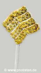

Achnanthes armillaris (O.F.Müller) Guiry 2019
Most likely ID: n.a.
Basionym: Conferva armillaris O.F.Müller 1783
Add’l Synonyms: Echinella stipitata Lyngbye 1819
Achnanthes longipes C.Agardh, nom. illeg. 1824
Sampling date 10/2008. Scale bars indicate 50 µm (1) and 25 µm (2, 3).
Three images.
Please click on < or > on the image edges or on the dots at the bottom edge of the images to browse through the slides!
Place name: Hiddensee Bodden (Germany)
Latitude: 54.582633 Longitude: 13.115051
Microscope Zeiss Universal, camera Olympus C7070WZ. DOF images.
Sampling date 10/2019. Scale bars indicate 50 µm.
Three images. Focus series, from the shell surface to the center plane.
Please click on < or > on the image edges or on the dots at the bottom edge of the images to browse through the slides!
Place name: Hiddensee Bodden (Germany)
Latitude: 54.582633 Longitude: 13.115051
Microscope Zeiss Universal, camera Olympus OM-D M5 MKII. DOF images.
Sampling date 04/2025. Scale bars indicate 20 µm (1), 500 nm (2).
Sampling and preparation for the light microscope by Hermann Hochmeier, Wilhelmsburg (Austria).
Two images showing high-resolution structural details of a diatom shell.
Please click on < or > on the image edges or on the dots at the bottom edge of the images to browse through the slides!
Place name: Heligoland harbor
Latitude: 54.177119 Longitude: 7.893548 Elevation: 0 m
Tescan Clara SEM, Tescan Clara SEM, © Wolfgang Bettighofer/Jürgen Stampfl
© Wolfgang Bettighofer,
images under Creative Commons License V 3.0 (CC BY-NC-SA).
For permission to use of (high resolution) images please contact postmaster@protisten.de.
